

This started as a trip to a church in the southern part of Armenia called Noravank. Not a big deal.
We’re going to get there by the end of this article, but we’re going to take a detour to explain something interesting along the way first. So I’ll drop us into the story right around noon, when I was riding shotgun in a large van, speeding southward along the Armenian-Turkish border.

My time in Armenia up to this point had been mostly green and lush, which wasn’t exactly what I pictured. Most of the footage of Armenia that I had seen prior to my arrival showed scraggily brown grass, which had been mostly absent save for the dusty Yerevan outskirts. But now we were taking the plunge southward, and the terrain quickly began to change.
Even before the greenery of agriculture started to fade away, huge, dusty, brown ridges rose up in the distance on either side of us. Suddenly our plain had become a valley. As the climate became hotter, hazier, and drier, it was clear that there was some state-of-the-art irrigation going on to keep these fields alive. But soon, that greenery started fade away too, leaving only desert.
Growing up, I did a fair bit of traveling around the American Southwest and Northern Mexico. This terrain looked a lot like that. The dirt and rock had a reddish tint to it, with only the hardiest foliage managing to make a home for itself. And although the signs were a combination of Russian and Armenian, there were other surreal similarities with these North American touch points. The 8th photograph down in this gallery shows the weird silhouette of a man sitting on the side of the road in the shade of his shack (where he was probably selling stuff), with a cowboy hat tipped downwards like Clint Eastwood. It was rugged but beautiful, and no doubt the last shift in climate before the Iranian border just a couple hundred kilometers in the distance. Here are some pictures from that drive.


So we were driving through the desert, well on our way to Noravank—but then something interesting happened.
I was checking our location on my Google Maps app, as is my habit when I’m taking any form of transportation through unknown territory without cellular data (because your location still updates automatically). On the map, I noticed that we were headed for a small bubble labeled as Azerbaijan. These sorts of enclaves are not uncommon along the Armenian / Azeri border, although this particular one was, admittedly, pretty small. To give you a few examples of enclaves that are more notable, do a quick Google search for “Nagorno-Karabakh” (an Armenian enclave surrounded by Azeri territory) and the “Nakhchivan Autonomous Republic” (an Azeri exclave). Those are big ones. This one… was very small. Almost comically small. Here it is on the map so you can see for yourself:
Now, if you don’t know, Armenia and Azerbaijan are still actively at war. And although the majority of the fighting is taking place on Armenia’s eastern border with Azerbaijan, there is also some fighting that happens along it’s western border with the Azeri-controlled Nakhchivan exclave. At this point, we were just a couple miles from that western border, and speeding ever closer to that little bubble on the map labeled “Azerbaijan.”

So I called over to our tour guide for the day and gestured to the phone in my hand.
“Does this mean we’re about to go through Azerbaijan?”
She laughed and said no. But, for the record, Google disagreed with her.
So we passed into and out of the little bubble, and nothing around us changed. There was no border, no structures indicating that anything had changed, no changes in signage. There was nothing. 🤷🏻♀️
About 15 minutes later that same road took us within 500 meters from the Armenian / Azeri border. At this point, as we drove more or less parallel with the border, our guide pointed out the window to identify a military compound that we were passing. She went on to tell us how there are often shots exchanged between Armenian and Azeri soldiers and/or snipers. She told us that at least a couple men die here every month.
“Um… should I like… keep my head down or something?”
Again, she laughed and said no.
Just then there was a loud whirring sound. It was a military helicopter flying low over the roof of our vehicle. I managed to snag a photo of it before it disappeared over the next bluff. 😬
This whole thing left me with a lot of unanswered questions. On paper, a lot of this felt like a series of red flags, but in reality, it all felt oddly benign. So I realize that this little narrative wasn’t the most climactic series of events, but I want to use it as an excuse to explore the surrounding circumstances. To understand any of this, there’s a lot of context that is needed. Hopefully I can make sense of all the factors at play around me here.
So let me start by explaining the war between Armenia and Azerbaijan…
Armenia’s War With Azerbaijan
Let’s rewind a few decades. Back then, Armenia and Azerbaijan were part of the same country: the Soviet Union. Both coexisted under the umbrella of the “Transcaucasian Socialist Federative Soviet Republic,” or the “TSFSR” for short. Within this, each was its own “Soviet Socialist Republic,” otherwise known as “SSR.” I started to explain this conflict in my first article about Yerevan, alluding to the fact that this article was coming to expand on more on this conflict.
If you missed that first post, here are a few choice passages to set the scene. If you want to get yourself caught up, you can jump back to that original post by clicking here 👍
“Ethnic tensions had been quietly (and sometimes not-so-quietly) simmering since the mid-1960s over a large Armenian enclave called Nagorno-Karabakh. Finally, in 1987, violent in-fighting began between the two groups. Soon Azerbaijan and Armenia were literally at war with one another, and the violence was escalating quickly. And remember, both of these were still SSRs, so this would technically have been a Civil War within the Soviet Union. Like if Texas went to war with Oklahoma.
I’m not gonna sugar-coat this—there were ethnically-motivated atrocities committed by both sides in the Nagorno-Karabakh War. Nobody’s hands are clean, and this got messy in a hurry. Soon Moscow sent Soviet troops to restore order to the region, but to read through the role that the Soviets actually ended up playing in this conflict, it’s very easy to forget that they had been sent to restore the peace. Often they seemed to be operating simply as a 3rd combatant in the conflict. Apparently they, at one point, literally laid siege to the Azeri capital of Baku, which was full of civilians.
By 1990, in addition to being at war with their Azeri neighbors, Armenia was also in open revolt against the Soviets. They declared their independence on September 21 1991, and 2 months later the Soviet Union collapsed. So that was it! Armenia was an independent nation again, and was instantly fighting for its life.
Turkey and Azerbaijan imposed a blockade on Armenia that all but crippled its economy during this conflict. In order to hold its own against Azerbaijan, Armenia was forced to direct all of its resources to the front lines. For Armenian citizens living back in Yerevan and the surrounding areas, they were essentially living through the Great Depression, with electricity often only available for about 1 hour per day. But Armenia held its own!
I’ll fast-forward through a few years of horribleness to 1994, when finally Russia brokered a cease-fire between the two fledgling nations. No actual resolution to the conflict has been achieved to date. In fact, the two nations are still sort of at war with one another, which is also something I’ll explain more in a forthcoming article.”
This is that forthcoming article! 🥂🎉
So that’s some history. Now, 25 years later, the nations are still actively at war with one another, and there doesn’t seem to be any end in sight. So let’s talk about what’s been going on since the “cease-fire.” If you’re feeling preemptively confused, ME TOO. It’s even confusing to people living these countries, so I’ll do my best to make this easy. But first, here’s a map of the region to give some context to what I’m about to tell you.

If you’re interested in the Caucasus region, you’ll start to hear the term “frozen conflict zone” thrown around a lot. Frozen conflict zones are areas where a military conflict fizzled to a stale-mate at some point in the past, but there was never any kind of agreement reached by the two sides of the conflict. So while, on paper, the area is still at war, in real life it’s actually now peaceful. This creates all kinds of weird dotted lines on maps in places where there should be normal borders. Almost of all of the world’s frozen conflict zones are located in former Soviet territory. So when you look at a map of Armenia at a glance, you might think to yourself “…well I see dotted lines instead of borders, and this IS the Caucasus… so these MUST be frozen conflict zones, right?”
Wrong.
I mean, you would have been correct at various points in the past, but today, in 2019, you would be wrong.
After the ceasefire in 1994, this region became a lot more low-key for a while. However, on paper, it was still at war, since no actual solution had been reached. This meant that for a quite a while, it would probably have qualified as a frozen conflict zone. There were small border clashes every so often, but nothing major happened until 2008. So that’s ~14 years of relative calm.
I’ve noticed a trend in this region—when it comes to political issues, a rising tide raises all boats. It doesn’t matter how peaceful these frozen conflict zones might feel at any given time. No matter their status, any sort of political unrest has the potential to translate into renewed violence along these ethnic and international fault lines, even if it has absolutely nothing to do anything! Everything is always very connected.
In 2008, there were mass protests in Armenia over a presidential election. And then, magically, fighting broke out along the Nagorno-Karabakh border. Once it blew over, both sides had differing narratives of who provoked who. I think the most likely scenario is that Azerbaijan hoped to strike a blow against Armenia while they were distracted with internal issues. But who knows. There were a bunch of these sorts of sketchy border clashes over the next 8 years, all hard to explain, all hopelessly tangled with the politics of the region.
Eventually, in April 2016, the two countries entered full-blown war again, for a period of 4 days. They call this “The 4 Day War.” A couple hundred soldiers died in total. After this was over, the region reverted back to a similar pattern of small border clashes, and that pattern continues to this day.
Violence Outside of The Battle Field
I don’t want to generalize… but Armenians and Azeri really hate each other. Like, way more than in normal conflicts between nations. I’m bringing this up because I think it’s also important to highlight that the violence in the Nagorno-Karabakh Conflict has not been limited to the battlefield.
In 2004, an Armenian soldier named Gurgen Margaryan was living in Budapest, Hungary, doing a 3 month English course as a part of NATO's Partnership for Peace program. He was living with a couple other Armenian soldiers in kind of a college-dorm set-up. In that program with them was an Azeri soldier named Ramil Safarov. One night, Ramil snuck into the quarters of these Armenian soldiers / students while they were sleeping. He brought with him a knife and an ax. He first went into Gurgen’s room, brutally murdering him. The autopsy revealed that he had stabbed him several times in the chest, and delivered 16 ax blows to his face, nearly severing his head from his body. From there we went on to the next room to do the same to the next Armenian soldier, but found the door locked. Meanwhile, the 3rd Armenian solider had already called the police. Ramil was promptly arrested, confessing to the murder during interrogation by Hungarian police. One Hungarian officer who responded to the scene remarked that the murder had been done "with unusual cruelty."
Ramil was sentenced to life in prison by Hungary, but was eventually handed over to Azerbaijan in 2012. Armenia was furious that Hungary cut his sentence short, and essentially cut diplomatic ties with them over the incident, because they knew what would happen to Ramil when he got back to Baku. The Azeri president pardoned him, and gave him a medal for heroism and bravery. In an interview, the Azeri president said “Yes, he is in Azerbaijan. This is a great news for all of us. It is very touching to see this son of the homeland, which was thrown in jail after he defended his country's honor and dignity of the people”
And here’s another disturbing quote from a prominent member of the Azeri political class about this: “Safarov is not just a hero of Azerbaijan, he is an international hero! A monument should be set up to him. Not every man could do this. I would have done exactly as Ramil did. He did the right thing to take the life of an Armenian.”

That’s some psycho shit.
As you can imagine, this made some waves with the Armenian public. Everybody in Armenia knows ALL about this, and no doubt feels quite validated in their ill-will towards Azerbaijan. And ya know what? I’m starting to agree with them! Armenia hasn’t been perfect in this, but if I had to choose a side, I’m gonna pick the one that doesn’t treat Jack the fucking Ripper like a national hero.
And this isn’t exactly an isolated incident. Apparently the was a recent incident where a group of Azeris threw an Armenian dude out the 3rd story window of a bar somewhere in Europe. Miraculously the Armenian guy survived the fall with no major injuries (which might be why I had trouble tracking down many sources on this), but it’s not hard to see why Armenians are so mistrustful of Azeris. This runs deep.
So now let me give you quick rundown of the two major oddities in the Azerbaijan / Armenia map…
Oddity #1: Nagorno-Karabakh (Enclave)
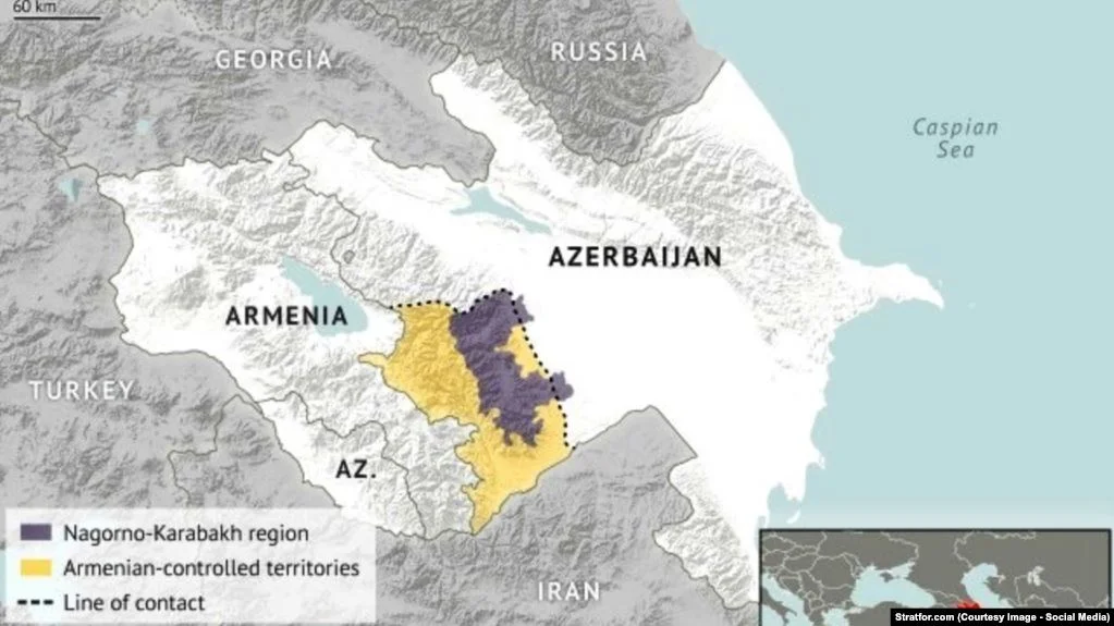
The first cartographical anomaly that I’ll touch on is Nagorno-Karabakh, which is the name sake of Armenia’s long-running war with Azerbaijan.
I’ll make this simple for you. Although the clean straight lines that separate countries and cultures from one another might suggest otherwise, the ethnographic spread of most regions is actually much more complicated. It’s hard to draw boundaries to separate two people groups because they are often interspersed, living amongst one another.
But it’s the nature of the modern age that we’ve got to draw concrete borders around everything. So when Stalin tried to draw those lines with the TSFSR (remember that acronym from earlier?) he had to make some tough choices. One of the choices that he made was to give the majority-Armenian region of Nagorno-Karabakh to the Azerbaijan SSR. He did this in order to placate Turkey (since Azerbaijan and Turkey are total butt buddies) for unrelated geopolitical reason. Because the Soviet Union had the area under such tight control, the issue sort of went away for a while. But when the Soviet Union started sliding downhill, this was the fuse on the dynamite that blew this region up.
Today you can actually travel here from Armenia, since they occupy most of it. However, if you do and Azerbaijan finds out about it, they probably will turn you away at customs. So if you want to do a comprehensive Caucasus trip, do Azerbaijan first. I didn’t go to Nagorno-Karabakh, but now I wish I would have. It’s an easy trip.
Oddity #2: Nakhchivan (Exclave)

Although Armenia does lay claim to this one, Azerbaijan is solidly in control here. This one isn’t as much of a war zone as Nagorno-Karabakh, but there is regular gunfire along the border apparently. I know this because I unwittingly found myself driving along this border earlier in this article.
The history here is basically that the numbers of Armenians vs. Azeris in this area had historically been pretty even, but in 1918 this area came under the rule of the Ottoman Empire, who purged the Armenians from this area in the Armenian Genocide, which you now know all about because of the article I wrote on it.
After that there was lots of violence here, with Armenia and Azerbaijan losing and re-taking control of the region repeatedly in what is now known as the Aras War. Finally, the Soviet Union stepped in and Nakhchivan was made into its own SSR to put the conflict to an end. Essentially, it’s like there were two children fighting over a toy, until finally their mom took the toy away and says “WELL NOW NOBODY GETS IT!” However, not long afterwards, the Soviets changed their minds and gave the “toy” to Azerbaijan because Turkey wanted to them to have it. Isn’t it crazy how much influence Turkey had over all of this? This was the Ottomans messing with Armenia even from the grave. Today it’s pretty much a foregone conclusion that this area will remain part of Azerbaijan, but Armenia is still fighting along this front.
Now do you see that little red dot on top of the main highlighted-red area on the map? That’s what I drove through. It’s a small town formerly known as “Karki” but has since been given a new Armenian name: “Tigranashen.” On paper it’s still part of Azerbaijan, but in reality it’s been part of Armenia since May 1992. The Azeris living here have since relocated to a neighboring region of the Nakhchivan Autonomous Republic.

Noravank Monastery
ANYWAY, back to the road trip! Once we got past the stretch of highway that ran right along the Armenia / Nakhchivan border, we pulled away into continued desert terrain, that eventually gave way to rugged canyon land. There were small buildings and make-shift fruit stands along the sides of the highway, perpetually locked in a swirl of hot dust. However, as the canyon walls heightened off in the distance on either side of us, we began to see pieces of greenery penetrating through the arid desert backdrop.
And then we took a sharp right turn down a narrow two lane road that led us off into a little nook in the canyon wall. As the road wound forwards, this nook continued to unfold before us like the 1990s Windows 3D maze screensaver. Here are a couple pictures from that road…


It wasn’t long before our van was climbing up a steep incline, eventually landing us in a hot parking lot look out over the valley through which we had just traveled. And off the our right, nestled up against the canyon wall, we saw our final destination: Noravank.
This church was built in the year 1205 and is famous for its striking location and architecture. There are a couple different structures here but the main chapel is called Surb Astvatsatsin (Holy Mother of God) church, which is 2 stories high. The only way to enter the 2nd story is to shimmy up an extremely narrow set of stairs that hug the stone wall at the front of the church, and have no guard rail to keep you from falling off. It’s not crazy high, but it will make your palms sweat to go up and down. Once I had managed to get my ass up to the top of this thing, I procrastinated going back down for a while because I knew it was going to be scary. I survived though.
Scattered around the grounds there are light fortifications, Khachkars (a.k.a. cross stones), and interesting carvings of biblical figures with distinctly Asian features. I would learn that these weird carvings were done while ancient Armenian was under the rule of Genghis Khan and the Mongol Empire. During this time the monks here tried throw some Asian flavors into their Christian traditions in an attempt to stay in the good graces of their conquerers. You’ll see one of these carvings in the gallery below.


At this point in my Armenia trip, I’d been to a lot of churches. It’s crazy to think that all of these places had been the home to real people who were essentially fending for themselves out here on these cliff-sides before there were roads connecting them to the outside world or anything like that. This canyon would have been particularly isolated, and difficult to build in. To say this terrain felt inhospitable would be an understatement. It was really pretty out here though, and Noravank was undoubtedly the coolest church that I had seen here so far.
From there we piled back into our van and began the long haul back to Yerevan, along the Nakhchivan border, past the Armenian military outposts, through the town of Karki a.k.a. Tigranashen, eventually making our way back into the shadow of Mount Ararat. I didn’t yet understand much about what we passed during this drive, but I was fascinated.
We’ve got ONE article left in this series in Armenia, and we’re going to use it to visit the most famous monastery in the whole country, and then take a swing through Armenia’s wine lands. 🍷🇦🇲🤙🏼